New Presidential Election Map Displays Importance of Toss-Up States
A new 2008 Presidential Election Map shows exactly how and why the presidential election is so close. The map shows how many people live in each state. It is made up of small grid squares. The bigger the state on the map, the greater the electoral clout. ODT also published an Equal Area Map of the USA, as well as the the Peters World Map which appeared on The West Wing. GIF images of ODT’s 2008 Presidential Election Map available free to individuals.
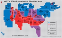
Amherst, MA, October 09, 2008 --(PR.com)-- ODT’s 2008 Presidential Election Map allows you to see exactly how and why the election is so close. This map ignores land mass in favor of one dimension only – how many people live in each state. Each of the map’s grid squares represents 250,000 people. On the map is the exact population of the larger states (for ease of comparison, and to eliminate the need to count individual blocks) along with each state’s electoral votes. The bigger the state on the map, the greater the electoral clout.
ODT’s 2008 Presidential Election Map was created by cartographer Paul Breding, former cartographer for the Chicago Tribune and an associate of ODTmaps.com, a publishing company specializing in innovative map images. Breding previously completed a similar World Population Map which is available at www.ODTmaps.com. ODT also published an Equal Area Map of the USA in 2007, where one can compare the exact size of each state to others. Black & white outline maps of the Equal Area USA map are available as free downloads, as are many other map resources. ODTmaps.com also published the Peters World Map which appeared on NBC's hit show, The West Wing, in 2002, and the Hobo-Dyer World Map which was used by President Jimmy Carter when he received the Nobel Peace Prize.
For interviews with Paul Breding or other ODT staff, contact 1-800-736-1293 or email odtstore@odt.org. GIF images of ODT’s 2008 Presidential Election Map are available free to individuals at www.ODTmaps.com. Photoshop images at larger sizes are available for purchase. The Photoshop images also include the ability to add layers of state capitals and major US cities.
###
Contact
ODTmaps.com
Bob Abramms
800-736-1293
www.ODTmaps.com
Fax: 413-549-3503
Bob Abramms
800-736-1293
www.ODTmaps.com
Fax: 413-549-3503
Categories