ODTmaps.com Releases a New World Population Map on World Population Day - July 11, 2015
The saying goes "a picture is worth 1,000 words"... and ODTmaps asserts that their new World Population Map is worth an entire encyclopedia. Each tiny square represents 1 million people… a map that shows people instead of land area. It also foretells the future of population growth and is a powerful way to communicate concerns about the human carbon footprint. Cartographer Paul Breding asserts that India will soon surpass China in population, probably between 2023 and 2028. - July 07, 2015
ODTmaps Honors Stuart McArthur on Australia Day 2015 - January 26th
Putting Australia at the top half of a map, as was done on McArthur's Universal Corrective Map, may seem like the work of some prankster in the Outback, but in fact, there is no intrinsic reason to put the Southern Hemisphere at the bottom of a map. ODTmaps now offers McArthur's provocative map in a variety of formats. - January 23, 2015
Report Reveals Startling Statistics
New statistics on resource use & inequality provides data on languages, housing, literacy, malnutrition, access to drinking water & use of electricity. - December 24, 2014
New Equal Area Map Kicked Up a Notch
The Hobo-Dyer map was originally designed by cartographers and social justice advocates in 2001. It attracted the attention of human rights advocacy groups worldwide and displayed the work of President Carter when he received the Nobel Peace Prize. In 2010 the Mead Art Museum at Amherst College produced a huge seven-foot wide map for one of their galleries. Now that same map at 36” wide is available to the public at modest prices in a variety of formats. - December 05, 2014
World Population Day – July 11, 2014 – Mapping the World’s People
World Population Day is July 11, 2014. In the past 10 years the global population has increased by 12.7%. A new World Population Map, just published by ODTmaps, has surprised both the publishers and cartographers. The new map visually shows dramatic increases in only ten years. Big Surprise: India will soon surpass China in population …probably between 2023 and 2028. From renowned map critic Denis Wood, “All I can say is: wow!" - July 11, 2014
Kaiser Launches Book Tour for Social Activists and Map-Lovers
Ward Kaiser’s new book, How Maps Change Things, explains how maps are really about politics and the values we hold. He contends that we need to become aware of how we shape and use maps, and how they in turn shape us. Ultimately, it's about becoming aware of the "hidden meaning" and values behind the maps we use so we can reflect on and begin to create the kind of world we want. Kaiser takes an informed and passionate view of how maps influence the significant paths we humans pursue. - October 23, 2013
Having Faith in Maps: a Values-Based Approach to Mapping; ODT, Inc Releases New Book
“Maps are verbs” is the author’s arresting statement at the outset of How Maps Change Things: A Conversation About the Maps We Choose and the World We Want. The book examines maps as change agents, reflecting intentions and setting agendas, often revealing who has power and resources and who has not. He explores the question, “What are the messages maps send?” - July 17, 2013
New Internationalist Magazine and ODTmaps.com Launch New Politically-Edgy eBook on Maps with Huge Viral Give-Away
Two organizations on opposite sides of the globe have collaborated to co-publish a new eBook designed to demystify maps, and help detect the hidden meanings behind them. How Maps Change Things: A Conversation About the Maps We Choose and the World We Want by Ward Kaiser is being released on March... - March 05, 2012
Maps, Verbs and a Birthday - ODTmaps.com Releases a New Ebook Celebrating Famous Mapmakers and Provocative Maps
The 500th birthday of Gerhard Mercator, is March 5...and his world map still impacts many people. Four centuries later Arno Peters, created a new world map that many praise as more accurate, but others see as distorted. Ward Kaiser’s new book How Maps Change Things investigates both maps and examines maps as change agents, reflecting intentions and agendas, revealing who has power and resources, and who has not. What are the messages maps send? Are maps simply propaganda for a hidden agenda? - March 01, 2012
"Maps That Stretch Minds" Contest Encourages Thinking "Outside the box"!
Nearly all world maps distort land areas, thus giving the viewer a false impression the relative sizes of the countries. Some educators, however, do use equal area world maps and they (and their students) will have an opportunity to share their stories and successes of how they use maps in the classroom. This media literacy contest is an opportunity to get teachers and students thinking about how we see the world around us. - August 16, 2011
New Exhibit, New Map at the Mead Art Museum
The Mead Art Museum at Amherst College, features a gallery, "A Global View." One entire wall includes ODT's unusual Hobo-Dyer equal-area map. What makes this map unique is that it is oriented with South at the top of the map. “This map allows Mead visitors to challenge their preconceptions,” said Elizabeth Barker, museum director and chief curator. “This is what a successful museum aims to accomplish.” ODT's Bob Abramms will give a presentation on world maps on Sunday, December 5, at 4 pm. - December 03, 2010
Famous Upside-Down View of World Now in Versatile New Size for Wider Use and More Occasions
ODT maps releases its best-selling upside-down world map in a new format... perfect for framing in a standard poster frame. As a recognized leader in publishing alternative world maps, ODT has published a new map to stretch your mind and make you think about the world in dramatically new ways. - May 18, 2010
ODT Releases New Desktop Peters Map
ODT Inc., the North American publisher of Arno Peters' famous equal-area world map, has just released a Peters desktop format map at 11” x 17.” The Peters Map, featured on the hit TV show “The West Wing,” is a provocative new way to look at the world…treating each country equally, without the bias or distortion of size that typically exaggerates the size and importance of the nations in the Northern Hemisphere. - October 27, 2009
Fair Trade Organization Celebrates World Population Month with ODT Maps
Ten Thousand Villages, a faith-based fair trade organization in Canada, committed to raising awareness around World Population issues this summer. In order to do this, they are featuring three unusual maps, helping first-world consumers realize that there are “Many Ways to See the World.” The maps include ODT’s World Population Map, the What´s Up? South! World Map, and the Peters Equal Area Map. Maps are now on display at over 40 stores across Canada. - July 31, 2009
NEMO 23rd Annual Meeting Features Arno Peters DVD and Behind the Scenes "Gossip"
The North East Map Organization meeting in Boston features a DVD presentation on the provocative Peters World Map. Dr. Bob Abramms, and his late mother, videographer Ruth Abrams, formerly of Brookline, MA, flew to Germany in 2001 to interview the controversial cartographer, Arno Peters, and filmed 25 hours of footage. The film was released in 2008 (trailer available on YouTube) and features a behind-the-scenes peek at the dynamics behind the creation of this revolutionary, world-changing map. - June 01, 2009
ODTMaps.com Acquires WorldEagle.com
World Eagle map publishing has been taken over by ODT Maps of Amherst Mass. Both businesses expand the public’s global awareness and perspective, seeing the developing nations through a lens that is non-traditional. They both offer a fresh point-of-view, one that brings a better understanding of non-American cultures to American audiences. Intellectual assets include the series of Global Perspective Maps drawn by Russell H. Lenz, Chief Cartographer of The Christian Science Monitor. - April 07, 2009
Buckminster Fuller´s Visionary Map for the 21st Century
Buckminster Fuller designed the Dymaxion World Map to help us recognize that ''we're all astronauts aboard a little spaceship called Earth.'' The map has just been reprinted in a variety of new formats. The Buckminster Fuller Institute co-published the map with ODTmaps, the leading map publishing firm specializing in alternative world views. The printing coincides with two new major exhibits of Fuller’s work - The Whitney Museum of American Art and the Museum of Contemporary Art in Chicago. - April 02, 2009
ODTmaps.com Author Presents Mapping the World: A Faith Perspective
Ward Kaiser presents a series of exciting and innovative events in Westerville, Ohio, February 21 – 22. Kaiser was the original English-language publisher of the Peters World Map. The map was featured on the West Wing Television show and created a firestorm of controversy within the cartographic establishment. The current series will explore how maps reflect our value systems and reshape and influence our values and faith. - February 06, 2009
Give the Holiday Gift of Self-Esteem to Your Loved Ones: ODT's Self-Esteem Passports Are the Ideal Stocking Stuffer
With the look and feel of a real passport, this booklet from ODTmaps.com is an engaging and upbeat resource for improving self-esteem - the "passport" to a happier, healthier life. Sections focus on the recognition of personal strengths, triumphs, and achievements -- the essential self-esteem catalysts. A great tool for individuals and groups, it also makes a fantastic holiday gift. - December 11, 2008
ODT Maps Offers Mind-Stretching World Maps for Holiday Gifts – at Budget Prices
Consumers are spending less this holiday season. One map publisher has responding to the grim economic outlook by offering 22 map items for $15 or less. ODT is well known for innovative and thought-provoking maps. Among ODT’s unique offerings are four different mind-stretching maps with South at the top. Price reductions range from 20% - 80%. - November 26, 2008
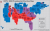
New Presidential Election Map Displays Importance of Toss-Up States
A new 2008 Presidential Election Map shows exactly how and why the presidential election is so close. The map shows how many people live in each state. It is made up of small grid squares. The bigger the state on the map, the greater the electoral clout. ODT also published an Equal Area Map of the USA, as well as the the Peters World Map which appeared on The West Wing. GIF images of ODT’s 2008 Presidential Election Map available free to individuals. - October 09, 2008
ODTmaps Expert Denis Wood Reveals the Hidden Messages of Maps
ODTmaps.com author and world-renowned alternative cartographer, Dr. Denis Wood, will explore the way maps shape our view of the world in his lecture, The Origins of Map Art, at the Contemporary Arts Center in Cincinnati, OH on Monday, June 9 at 6:30 pm. Dr. Wood traces the trajectory of map art since the early 20th century. Wood poses a key question: “If we equate maps with truth, what power does the mapmaker possess?” - June 08, 2008
Map Expert Denis Wood From ODTmaps.com Featured on Radio Islam Call-in Show Friday May 30th
Dr. Denis Wood discusses the nature and meaning of maps on Radio Islam. ODTmaps.com's map expert will challenge the world-view encouraged by many traditional maps, and will discuss a variety of map images and the messages they communicate. Maps imply a truth, but that truth can be quite skewed depending on the viewpoint of the map creator. Wood co-authored Seeing Through Maps, which takes a hard look at truth by carefully inspecting some familiar, and not-so-familiar, map images. - May 27, 2008
Arno Peters: Radical Map, Remarkable Man – New DVD by ODTmaps.com
Ever wonder about how maps are created? Here is a DVD that explores the hidden political messages that maps send. The Peters Map was featured on an episode of NBC’s The West Wing, and many viewers thought the map was a hoax. But the map is real, even though the TV show was fiction. This documentary film traces the controversy and conflict the Peters World Map generated and challenges viewers to think critically about media messages of all kinds. - April 18, 2008
Premiere of ODTmaps.com New Map DVD - "Many Ways to See the World"
Anchorage, Alaska will host a premiere of the DVD, Many Ways to See the World, a fascinating 30-minute exploration into the challenges of creating a map and the minds of twelve visionary mapmakers. Howard Zinn, author of A People’s History of the United States says: “Many Ways To See The World is more than a fascinating lesson about maps. It opens the mind of the viewer to profound perspectives on the interconnectedness of human beings everywhere.” - April 02, 2008
Map Book & DVD Featured on National Public Radio
Glen Busby, producer of The Best of Our Knowledge, is doing two shows on the Seeing Through Maps book, and the Many Ways to See the World DVD. These broadcasts on maps, and how they shape our perceptions of the world, will feature Denis Wood, and also make reference to the Ontario Alliance of Christian Schools, serving 14,000 students in over 80 schools, and using ODT's new book and DVD as a core part of their curriculum, Canada Reaching Beyond its Borders, to encourage global awareness. - December 10, 2007
Map Movie Premiere in Boston on November 10th
A fabulous story about maps, and how a revolutionary, world-changing map was created by Dr. Arno Peters of Bremen Germany. Ruth Abrams and Bob Abramms, a mother-son team, filmed 25 hours of interviews and created this innovative teaching tool showing the power of maps and the effect maps have on our view of the world. The event, sponsored by ODT, is free, with a question & answer period following the 30-minute film. - October 11, 2007
New Format for Map Used in Presidential Peace Prize Ceremony
ODT's Equal Area World Map, the Hobo-Dyer Projection, shows all countries at true size and in true proportion. It can be seen at ODTmaps.com. This map was created in 2001, and received worldwide exposure in 2002 when President Jimmy Carter received the Nobel Peace Prize illustrating the Carter Center's work on this new map projection. The Hobo-Dyer map is an equal area map and it has just been released in an updated revised version at http://odtmaps.com/detail.asp_Q_product_id_E_HDP-1 - September 24, 2007
Peters Puts the Pacific in the Middle
The equal area Peters Map has attracted more press coverage, both praise and criticism, than any other map in history. It was featured in the hit TV show,The West Wing. Now, for the first time in North America, the Peters Map is available with one more novel, thought-provoking twist... the Pacific Ocean is in the middle. The map can be seen at http://odtmaps.com/detail.asp_Q_product_id_E_PCP-20-5x32 - September 12, 2007
Back-to-School with a Whole New View of the USA
Why a new USA map? Many Alaskan middle school students believe their home state is an island located in the South Pacific. Why? Because that's how it appears on most maps. Texas is often described as the largest state in the USA. Why? Because that's how it appears on most maps. Can a map of the... - September 02, 2007