Stonehenge: Geological Feature Indicates the Site Was Constructed at the End of the Last Ice Age, 14,000 Years Ago
As the spotlight turns once again on Stonehenge a British born amateur geologist, Dean Talboys, believes he has rediscovered a geological feature of the site which could give an indication of its true age. In dating the site archeologists have only ever considered radiocarbon determination of samples recovered during excavations. However, Talboys claims that these only indicate periods of activity at the site and not the original date of construction.
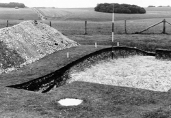
London, United Kingdom, September 26, 2008 --(PR.com)-- Unlike other 'contemporary' earthworks Stonehenge consists of an outer Ditch and inner Bank encircling the most familiar of all features, the large stone setting. The casual observer could be forgiven for missing the Bank and Ditch altogether for, although they form a circle of radius 50m (164ft), very little remains of the former and the latter is all but filled in. In the book, Stonehenge, Professor Richard Atkinson[1] describes the Bank as being 6m (20ft) wide with an estimated original height of at least 2m (6ft), and possibly more, based on the volume of material excavated from the Ditch, which would have washed back within a century or two of construction. However, in describing a cross-section of the Bank Atkinson also observed:
"... its actual height is even less than it appears, for excavation in 1954 revealed the surprising fact that the surface of the natural chalk is nearly a foot higher [30cm] beneath the centre of the bank than it is elsewhere. This is due to the gradual dissolution of the chalk by the acidity of percolating rain-water during the course of the centuries ... Only where the surface has been protected by the bank above it has this process of weathering been prevented, or at least slowed down."
His observation has been totally overlooked in Stonehenge In Its Landscape, the extensive re-evaluation of all the evidence from 20th excavations undertaken by English Heritage[2]. On the subject of the Bank and Counterscarp Bank (on the outer side of the Ditch) they have this to say:
"There is very little available information about the Bank because, unlike the Ditch, very little has been excavated ... Atkinson et al opened a wider section across the Bank here in 1954 (C44). Otherwise, the only description of the Bank comes from John Evans's reopening of C42/43 (C61) ... There is virtually no information available for the trench across the Bank contiguous with C18 by Atkinson et al (C44)."
Though Atkinson does not refer to the excavation by name it is safe to assume from the date (1954) that he is talking about C44 from which we might have expected at least a quote to be included in the book by English Heritage (they do, after all, quote other observations made by excavators). Perhaps it was an oversight, but had the authors been paying more attention they might have questioned exactly how long it takes for chalk to dissolve because the answer could give a better idea of when the Bank was constructed than the radiocarbon dating of animal remains in the Ditch rain-wash.
A study of carbonate erosion rates undertaken by Kevin Allred[3] in Southeast Alaska gives some idea of how long this process can take. The area in question, also known as the Panhandle, sits between latitudes 55-57°N. Annual rainfall varies from an average 1.75m to over 2.5m, or about two to three times that on Salisbury Plain at present. Allred's method involved gluing stainless steel bolts into the bedrock and using a Rock Erosion Meter to measure the increase in gap between the bolt head and rock surface following a period of erosion. A total of 582 points were measured in five different types of landscape. Results over a period of seven years from the clearcut (deforested) soil-covered sites most comparable to the landscape of Salisbury Plain showed an annual rate of erosion from 0.0-0.8483mm per year. The calculated rate per 1000 years was 32.81-71.60mm. At these rates it would take between 8,000-27,000 years for the surface at Stonehenge to erode by 30cm. Another study undertaken on exposed Alpine limestone surfaces at Innerbergli, Switzerland[4], where 29 year old rock paintings have prevented the underlying rock from corrosion, returned an overall average of 0.014mm per year. At that rate it would take over 21,000 years for Stonehenge to erode (the total precipitation is twice that experienced on Salisbury Plain but only half is rainfall). Clearly, if Atkinson’s observations are reliable, the geological age of the Bank has to be a lot older than the 5,000-year-old radiocarbon dated animal samples from the Ditch.
There is another reason to believe Stonehenge was built a very long time before the late Neolithic favored by British archaeologists. D. Q. Bowen[5], Professor of Earth Sciences at Cardiff University, has applied Chlorine-36 dating on a sample of igneous rock, or Bluestone, from Stonehenge (albeit one that is held in the Salisbury Museum). The method returns an estimate of the length of time a rock surface has been exposed to the atmosphere by frost shattering, quarrying or dressing and, in this case, showed the specimen was first exposed to the air 14,000 years ago. In contrast, Bowen’s results from Carn Menyn, Prescelly, the known source of the Bluestones, indicates quarrying had ceased there at least one thousand years before the stones are supposed to have arrived at Stonehenge. It would also be possible to date construction at Stonehenge by using Optically Stimulated Luminescence[6] (OSL) to test an exposed surface of a Sarsen pillar against the surface hidden beneath its lintel. OSL is a relatively new technique which can, under the right conditions, determine how much time has elapsed since minerals like quartz and feldspar were last exposed to sunlight. The charge within these crystal’s structures accumulates naturally but is emptied on exposure to sunlight; the longer the exposure the more complete the bleaching effect. The same process can be reproduced under laboratory conditions to measure the amount of charge remaining in a crystal’s structure. The length of time a block of stone remains exposed prior to placement in a monument would be sufficient to completely zero the meter to a uniform depth, so the difference in charge between the crystals in the exposed and hidden surfaces (i.e. from the overlaying of other blocks or partial burial in the ground) provide an accurate chronometer. For example, two pyramids believed to date to the Hellenic period (300-400BC) were OSL dated to more than 2000 years earlier, the original date attributed to reconstructions and repairs. For some reason English Heritage and the UK Government are reluctant to allow any direct physical or chemical testing of the stones at the Stonehenge site.
A date of construction around 14,000 years ago would place Stonehenge at the end of the last Ice Age shortly before the Younger Dryas period (12,800-11,500 BP) during which the Northern Hemisphere saw a rapid but brief return to glacial conditions. Though scientists are not sure of the reason for this 1,300 year cold snap they do know it ended with temperatures soaring by 5°C in less than three years. As current global temperatures continue to rise at an alarming rate the prospect that Stonehenge, whatever its original purpose, might be the only visible evidence to survive an event capable of removing every other trace of the civilization that designed and built it must raise doubts over our own vulnerability.
References:
1. Stonehenge, Atkinson, R.J.C., Pelican Books, 1960
2. Stonehenge in its Landscape, Cleal, R.M.J., Walker, K.E., Montague, R.,
English Heritage Arch Rep., 1995
3. Some Carbonate Erosion Rates of Southeast Alaska, Allred, K.,
Journal of Cave and Karst Studies, 2004, Volume 66 No. 3
4. Surface corrosion of an Alpine karren field: recent measures at Innerbergli
(Siebenhengste, Switzerland), Häuselmann, P.,
International Journal of Speleology, 37 (2), 107-111 Bologna (Italy). July 2008
5. Bowen 1994: 211; Hawkes 1994, British Archaeology News 1995
6. Dating of two Hellenic pyramids by a novel application of thermoluminescence
Theocaris, P., Liritzis, I., Galloway, R.B.
Archaeological Science, 1994, Vol. 24, 399-405
###
Contact
The Stonehenge Observatory
Dean Talboys
+34 646750421
www.stonehengeobservatory.com
http://www.louistalboys.com/stonehenge/article6.htm
Dean Talboys
+34 646750421
www.stonehengeobservatory.com
http://www.louistalboys.com/stonehenge/article6.htm
Categories