Tuvalu Visualization Project Was Launched
Tuvalu Visualization Project is an art project visualizing information of Tuvalu on Google Earth. This project has been executed as a joint research of NPO Tuvalu Overview and Hidenori Watanave Laboratory @ Tokyo Metropolitan University from September 2008.
Tokyo, Japan, October 04, 2009 --(PR.com)-- Tuvalu Visualization Project is an art project visualizing information of Tuvalu on Google Earth. This project has been executed as a joint research of NPO Tuvalu Overview and Hidenori Watanave Laboratory @ Tokyo Metropolitan University from September 2008.
Official website:
http://tv.mapping.jp/
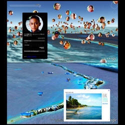
This project is composed of three elements.
1)Build the Future with 10,000 Tuvaluans
- The supporting system for the activity of Tuvalu Overview.
2)Tuvalu Mapping
- 3300 GPS photographs of Tuvalu on Google Earth.
3)Tuvalu on Photosynth
- Examples of artwork made by using GPS photographs.
The purpose of project is to disclose actual information about People and Scenery in Tuvalu to the world.
It is said that Tuvalu is exposed to danger of going under water by sea level rising because of global warming. However, we suppose that it is important to understand not only the problem of global warming, but also the real situation of Tuvalu. The Internet is an effective tool for collecting information, but it was difficult to obtain information of the real situation of Tuvalu from the Internet.
Therefore, this project was produced to present the real situation of Tuvalu, to improve the interest in Tuvalu, and to receive feedback from all over the world.
Credits:
NPO Tuvalu Overview
+
Hidenori Watanave Laboratory, Tokyo Metropolitan University
(Makiko Suzuki, Yuichi Watanabe, and Hidenori Watanave)
###
Official website:
http://tv.mapping.jp/
This project is composed of three elements.
1)Build the Future with 10,000 Tuvaluans
- The supporting system for the activity of Tuvalu Overview.
2)Tuvalu Mapping
- 3300 GPS photographs of Tuvalu on Google Earth.
3)Tuvalu on Photosynth
- Examples of artwork made by using GPS photographs.
The purpose of project is to disclose actual information about People and Scenery in Tuvalu to the world.
It is said that Tuvalu is exposed to danger of going under water by sea level rising because of global warming. However, we suppose that it is important to understand not only the problem of global warming, but also the real situation of Tuvalu. The Internet is an effective tool for collecting information, but it was difficult to obtain information of the real situation of Tuvalu from the Internet.
Therefore, this project was produced to present the real situation of Tuvalu, to improve the interest in Tuvalu, and to receive feedback from all over the world.
Credits:
NPO Tuvalu Overview
+
Hidenori Watanave Laboratory, Tokyo Metropolitan University
(Makiko Suzuki, Yuichi Watanabe, and Hidenori Watanave)
###
Contact
Hidenori Watanave Laboratory, Tokyo Metropolitan University
Hidenori Watanave
81-3-5531-2132
archidemo.blogspot.com/
Hidenori Watanave
81-3-5531-2132
archidemo.blogspot.com/
Categories