River Ecosystems, Inc. Releases an Analysis of the Impacts of Disrupted Sediment Transport Along the Missouri River, May 2026
New Orleans is sinking, sea level rise will soon surround the city, and sediment from the Mississippi River has been unavailable since the 1950s. Missouri River sediment, stored in reservoirs and on the lower river floodplain could mitigate this outcome, and would, most assuredly benefit the ecosystems.
Crofton, NE, May 09, 2026 --(PR.com)-- Hiram Martin Chittenden (1903) wrote in: The History of Steamboat Navigation on the Missouri River, “of the immense carrying power and potential energy of this stream, it is difficult to form an adequate conception. It yearly carries, into the Mississippi River, 550,000,000 tons of earth, which is brought no less than 500 miles. The work is equivalent to 275 billion ton-miles.”
Prior to dams and bank stabilization, the Corps of Engineers (1984, A History of the Omaha District U.S. Army Corps of Engineers) estimated that the river eroded floodplain lands, totaling 9,094 acres/year.
Before 1900, the Missouri River, and the Mississippi River, transported this sediment to coastal Louisiana. The Missouri River contributed >75% of the sediment in the Mississippi River. After every tributary, excluding the Yellowstone River was dammed; 16 dams were built on the main stem; and bank erosion from 750 miles of the channelized river was eliminated, only a fraction of this sediment reaches the coast (USGS Scientific Investigations Report 2011-5200, Trends in Suspended-Sediment Loads in the Mississippi River Basin, 1950-2009).
The Missouri River Basin soils were sugar fine, composed mostly of silt and clay, which were infused with essential nutrients, and particulate organic carbon. The Missouri River contributed at least 75% of the nutrients and organic carbon to the lower Mississippi, and the Gulf. The loss of sediment, carbon, and nutrients, has had a profound effect, on the fish and shellfish, of the Missouri, Mississippi, and Gulf of Mexico (L.W. Hesse. 2025. "8emessourit" 'The River of the Big Canoes' A Large, National, River Ecosystem in Peril).
In addition, engineering disconnected the Missouri River from its floodplain (channelization and incision), or has completely inundated the floodplain by reservoir construction. As a result, 4,456,756 acres of the river/floodplain system’s morphology, has been destroyed. Nearly all terrestrial wood, grass, forbs, and wetland/marsh plants have been eliminated. This was the total energy supply for the aquatic space. The organic carbon load delivered to the Mississippi River annually, exceeded 154,020,480 pounds in 1892; the load was reduced to 53,953,480 pounds by 1982, a 65% reduction, and channelization/bank stabilization, and reservoir retention is unabated (L.W. Hesse, 2026. "The Magnitude of What Has Been Done to the Missouri River" Published on LinkedIn).
National Public Radio, Morning Edition, 6 May 2026, presented a discussion with Dr. Jesse M. Keenan, Tulane University, New Orleans. The following news release highlights the threat this city faces.
New Orleans could face collapse, study warns, urging relocation to start immediately
Jesse Keenan, one of the study’s authors, said leaders should begin planning for relocation immediately, by The News Digital, Published May 04, 2026.
Dr. Keenan stated in the NPR interview, that the Corps is investigating available sources of sediment in the lower Mississippi, to extend the timeline for the permanent flooding of New Orleans.
The White River (NE and SD), annually, discharges 7 million metric tons of sand, clay, and volcanic ash into Lake Francis Case, and the Niobrara River, and Ponca Creek, discharges approximately 5,000 metric tons, into Lewis and Clark Lake (L.W. Hesse. 2026. "Sediment and Fish Passage: Lake Francis Case and Lewis and Clark Lake, Missouri River." Published on LinkedIn). These are the two lowermost reservoirs on the Missouri River; Projects have been proposed to move this sediment downstream. In addition, the Hamburg Bend project, in the channelized section, if widened to the maximum width, would slowly contribute >5,000 acres to the lower Missouri, the Mississippi, and the Gulf. These actions are also, essential for recovery, of the Missouri River ecosystem.
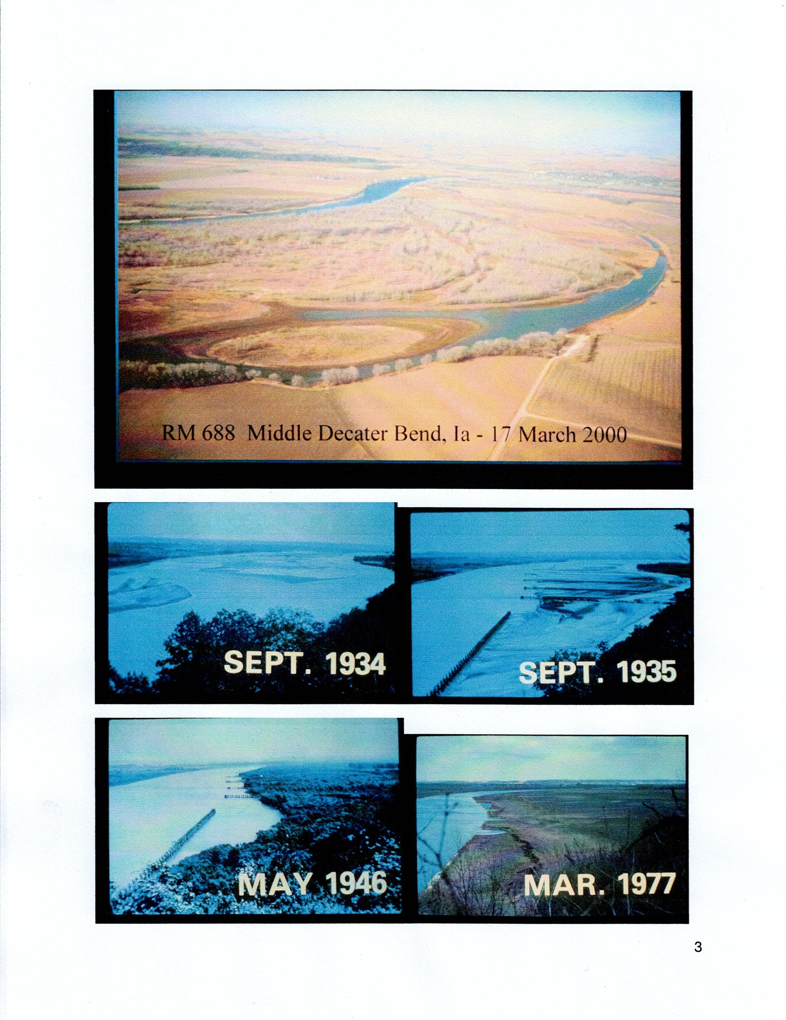
The following photos show the sediment, that has been trapped behind dikes and revetments, at one bend on the channelized Missouri River. Fifteen, similar bends that are publicly owned, could be managed in a similar manner, The transition from original condition in 1934, to dikes collecting sediment by 1935, to dense forest by 1946, and subsequently, cleared for agriculture by 1977, is the fate imposed on 750 miles of channelized river, from Ponca, NE, to the Mississippi-Missouri River’s confluence.
Contact
River Ecosystems, Inc.
Lawrence W. Hesse
402-640-7809
reieco3@gmail.com
Prior to dams and bank stabilization, the Corps of Engineers (1984, A History of the Omaha District U.S. Army Corps of Engineers) estimated that the river eroded floodplain lands, totaling 9,094 acres/year.
Before 1900, the Missouri River, and the Mississippi River, transported this sediment to coastal Louisiana. The Missouri River contributed >75% of the sediment in the Mississippi River. After every tributary, excluding the Yellowstone River was dammed; 16 dams were built on the main stem; and bank erosion from 750 miles of the channelized river was eliminated, only a fraction of this sediment reaches the coast (USGS Scientific Investigations Report 2011-5200, Trends in Suspended-Sediment Loads in the Mississippi River Basin, 1950-2009).
The Missouri River Basin soils were sugar fine, composed mostly of silt and clay, which were infused with essential nutrients, and particulate organic carbon. The Missouri River contributed at least 75% of the nutrients and organic carbon to the lower Mississippi, and the Gulf. The loss of sediment, carbon, and nutrients, has had a profound effect, on the fish and shellfish, of the Missouri, Mississippi, and Gulf of Mexico (L.W. Hesse. 2025. "8emessourit" 'The River of the Big Canoes' A Large, National, River Ecosystem in Peril).
In addition, engineering disconnected the Missouri River from its floodplain (channelization and incision), or has completely inundated the floodplain by reservoir construction. As a result, 4,456,756 acres of the river/floodplain system’s morphology, has been destroyed. Nearly all terrestrial wood, grass, forbs, and wetland/marsh plants have been eliminated. This was the total energy supply for the aquatic space. The organic carbon load delivered to the Mississippi River annually, exceeded 154,020,480 pounds in 1892; the load was reduced to 53,953,480 pounds by 1982, a 65% reduction, and channelization/bank stabilization, and reservoir retention is unabated (L.W. Hesse, 2026. "The Magnitude of What Has Been Done to the Missouri River" Published on LinkedIn).
National Public Radio, Morning Edition, 6 May 2026, presented a discussion with Dr. Jesse M. Keenan, Tulane University, New Orleans. The following news release highlights the threat this city faces.
New Orleans could face collapse, study warns, urging relocation to start immediately
Jesse Keenan, one of the study’s authors, said leaders should begin planning for relocation immediately, by The News Digital, Published May 04, 2026.
Dr. Keenan stated in the NPR interview, that the Corps is investigating available sources of sediment in the lower Mississippi, to extend the timeline for the permanent flooding of New Orleans.
The White River (NE and SD), annually, discharges 7 million metric tons of sand, clay, and volcanic ash into Lake Francis Case, and the Niobrara River, and Ponca Creek, discharges approximately 5,000 metric tons, into Lewis and Clark Lake (L.W. Hesse. 2026. "Sediment and Fish Passage: Lake Francis Case and Lewis and Clark Lake, Missouri River." Published on LinkedIn). These are the two lowermost reservoirs on the Missouri River; Projects have been proposed to move this sediment downstream. In addition, the Hamburg Bend project, in the channelized section, if widened to the maximum width, would slowly contribute >5,000 acres to the lower Missouri, the Mississippi, and the Gulf. These actions are also, essential for recovery, of the Missouri River ecosystem.
The following photos show the sediment, that has been trapped behind dikes and revetments, at one bend on the channelized Missouri River. Fifteen, similar bends that are publicly owned, could be managed in a similar manner, The transition from original condition in 1934, to dikes collecting sediment by 1935, to dense forest by 1946, and subsequently, cleared for agriculture by 1977, is the fate imposed on 750 miles of channelized river, from Ponca, NE, to the Mississippi-Missouri River’s confluence.
Contact
River Ecosystems, Inc.
Lawrence W. Hesse
402-640-7809
reieco3@gmail.com
Contact
River Ecosystems, Inc
Lawrence W. Hesse
402-640-7809
https://www.linkedin.com/in/larry-hesse-522ba1346/
Lawrence W. Hesse
Lawrence W. Hesse
402-640-7809
https://www.linkedin.com/in/larry-hesse-522ba1346/
Lawrence W. Hesse
Categories