Fledermaus Technology Used in 1400 Meter Plume Discovery Off the Northern California Coast
Latest Technology from IVS 3D Used to Visualize Massive Plume. Read more about the discovery and view 3D video of the analysis.
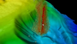
Portsmouth, NH, September 23, 2009 --(PR.com)-- Fledermaus’ latest technology, mid-water visualization, has helped scientists to discover a 1400-meter plume off the northern California margin.
While on a cruise to test the new Kongsberg EM302 multibeam sonar in May 2009, the NOAA ship Okeanos Explorer, discovered a 1400 m high plume rising from the seafloor. The feature was noticed in the online display of the water-column data of the sonar, and further analyzed in the new Fledermaus mid-water visualization tool. The ship returned to the area in July, verified that the plume was still active, and detected a number of other plumes ranging in height from 700 to 1400 m in a 15 km area around the original discovery.
James V. Gardner and Mashkoor Malik (of The Center for Coastal & Ocean Mapping (CCOM) UNH and NOAA, respectively) participated on the cruise, and provided details of the discovery in the August 11, 2009 issue of EOS. Scientists cannot yet be certain of the composition, but they do feel reasonably certain that the plume is not a hydrothermal vent associated with the eastern section of the Mendocino Fracture Zone. The region is known for both subsurface and water-column gas; however, the reported gas plumes are confined to water depths of less than 200 meters. The discovery of this plume is significant because none has been reported in this area from such depths.
Moe Doucet, Chief System Architect for IVS 3D, noted. “IVS 3D jointly funded a project with a grant from the New Hampshire Innovation Research Center to support CCOM in the ongoing research and development of tools for the analysis and exploitation of multibeam sonar water column data. Until now, the users of these sonars had a limited view of the mid-water data in real-time, and limited capacity to store it, replay it, or run further analysis. The data also needs to be integrated with other sensor assets such as bathymetry, backscatter, sub-bottom, sea-floor characterizations and other assets so that a ‘complete’ picture of the marine environment under analysis can be realized. This discovery is just one example of the emerging uses of this type of data analysis.”
A video of the plume discovery is available on the IVS website, courtesy of CCOM and NOAA.
Interactive Visualization Systems (IVS 3D) was founded in 1995 as the developer of the Fledermaus 3D visualization and analysis software suite. Government, commercial and academic clients in all areas of ocean mapping use the software internationally.
The Fledermaus software stands apart in providing scientists and engineers with interactive and intuitive tools for processing, quality control, and analysis of multibeam sonar and related data. Its use significantly improves efficiencies in areas such as; nautical charting, geologic interpretation, the assessment of seabed habitats, planning routes for pipelines and cables, and the identification of geohazards during engineering development.
IVS 3D has offices in Canada, USA, and the UK, and a worldwide distribution network. For more information about the company and products, visit www.ivs3d.com.
###
Contact
IVS 3D
Carole Mahoney
603-431-1773
www.ivs3d.com
Carole Mahoney
603-431-1773
www.ivs3d.com
Categories