Geosemble, BAE Systems Strengthen Product Integration
Two companies integrate technology to deliver deeper understanding of geographic regions through database analysis and social media visualization
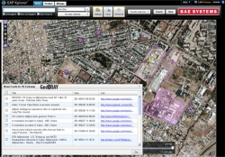
Manhattan Beach, CA, February 21, 2012 --(PR.com)-- Geosemble Technologies®, Inc., and BAE Systems have expanded their collaboration to integrate Geosemble’s GeoXray™ data-to-knowledge application and BAE Systems’ GXP Xplorer data discovery and retrieval software. Together, the system captures a wide range of organizational and Internet-based knowledge about a given geographic area while giving users control over tuning and filtering content of interest.
“GXP Xplorer is integrated, or ‘mashed-up’ with the GeoXray server that monitors news websites, blogs, Twitter tweets, and Facebook posts, and geotags the information so it can be discovered in a single search by GXP Xplorer users,” said Janis McArthur, product manager for GXP Xplorer. The combined capability leverages GXP Xplorer’s strength in cataloging and federating multiple data stores — images, maps, terrain, videos, and documents — with GeoXray’s functionality for automatic mining and integration of geographically relevant news and social media.
As part of the collaboration, BAE Systems and Geosemble jointly demonstrated the integrated product on desktop and handheld devices at the October GEOINT 2011 Symposium in San Antonio.
By working together, Geosemble and BAE Systems offer users the capability to search online information simultaneously with documents and files contained in an organization’s data stores for unique insight and accelerated mission effectiveness with fewer human resources required.
About BAE Systems
BAE Systems’ Geospatial eXploitation Products (GXP) business provides commercial off-the-shelf software capabilities and geospatial R&D technology. GXP Xplorer is a revolutionary data management application that makes it easy to access and share geospatial information across multiple data sources using a single query. The software is beneficial for a broad spectrum of military, defense, and commercial users who need to quickly sort through, catalog, and process large data repositories and share information with others.
About Geosemble
Geosemble’s products help organizations search, discover and manage text information geographically. The company’s flagship product GeoXray, automatically links unstructured content to locations at scale and allows users to peruse the latest information about a location or filter for topics and time frames of interest. The output of GeoXray can be tapped via API and displayed on a variety of systems, or on its own native GeoXray viewer. Uses for the product include Government and Military programs, municipal redevelopment, Business Intelligence and Enterprise Search, and geographic content delivery for mobile phone users. Geosemble is an In-Q-Tel portfolio company, a DARPA SBIR Phase II contractor, a strategic Google Earth™ Enterprise Partner, and a developer in the Oracle® PartnerNetwork. Geosemble Technologies, Inc. is privately held. Learn more at http://www.geosemble.com.
###
Contact
Geosemble Technologies
Joe Letterman
310 356 8307 x 7001
www.geosemble.com
Joe Letterman
310 356 8307 x 7001
www.geosemble.com
Categories