NEOS, Ltd. Launches a Wildfire Risk and Mitigation Service in California
NEOS, Ltd. has launched FireWatch, a new aerial remote sensing service that detects high-risk residential fire zones in Southern California.
San Diego, CA, September 24, 2018 --(PR.com)-- NEOS, Ltd. has launched FireWatch, a revolutionary aerial remote sensing service that detects high-risk residential fire zones and offers mitigation strategies before the onset of wildfires.
Over a decade of research and analysis of aerial imagery collected by NEOS from previous California wildfires has provided valuable information on the risk factors leading to extensive property damage during catastrophic firestorms driven by dry, gusty winds.
“The majority of property destroyed by wildfires failed to meet the defensible space requirements mandated by state law. Yet, flammable vegetation in proximity to structures is the single greatest predictor of property destruction,” said Richard McCreight, founder of NEOS, Ltd.
“FireWatch provides vulnerable communities with invaluable information about the level of imminent fire risk as well as the solution to manage that risk.” FireWatch determines the location and quantity of vegetative fuel surrounding properties and outlines the areas recommended for clearing. Through fire simulation modeling, risk mitigation strategies can be evaluated before implementing solutions.
For more information on FireWatch, please contact Richard McCreight to learn how this affordable service can help predict, document, and reduce risks from wildfires.
About NEOS, Ltd.
NEOS, Ltd., a spinoff of NASA research, offers an integrated approach to environmental monitoring by using the latest remote sensing and geographic information systems (GIS) technology. NEOS founder, Richard McCreight, has worked on 75 California wildfires with the U.S. Forest Service as both a firefighter and fire researcher, documenting major wildfire impacts in California. He is currently an active participant of the NASA and USFS Tactical Remote Sensing Advisory Committee.
Contact
NEOS, Ltd.
Richard McCreight
858-344-5161
www.neos500.com
Richard McCreight
858-344-5161
www.neos500.com
Multimedia
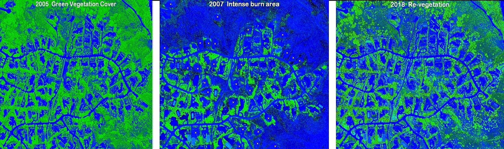
Enhanced Aerial Imagery created by FireWatch
Green vegetation that was later identified as highly flammable fuel during the 2007 Witch Creek wildfire resulted in the destruction of 77 homes in the Rancho Bernardo Trails community, CA
Categories