Geosemble Wins DARPA Contract for Satellite Image Data Integration
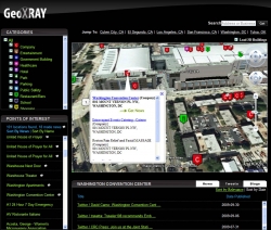
By clicking a given point on an aerial image, GeoXray™ users can view news, video, audio, text documents and other information relevant to a specific location.
El Segundo, CA, October 06, 2009 --(PR.com)-- Geosemble® Technologies, Inc., the leader in embedding data in satellite and aerial imagery, announced today a Phase II development contract with the Defense Advanced Research Projects Agency (DARPA) that will enable its current GeoXray data integration software to display a greater range of location-specific information.
Geosemble’s new DARPA program will build upon the company’s capability for assigning textual keywords to geospatial datasets. Geosemble will focus on expanding its range of information sources beyond text to include video and audio sources, where summarized data is displayed chronologically on an intuitive, user-friendly interface. The system will also have expanded geographic coverage. As part of the program, Geosemble will subcontract to the University of Southern California (USC) for technology development in summarizing text documents.
Todd Hughes, DARPA program manager, observed that “An integrated interface makes it simple for anyone to view a satellite image of any place in the world, then click on a location or object to automatically extract relevant information. The application uses automatic techniques to accurately display geographically relevant news articles, business intelligence, events and databases onto satellite and aerial imagery.”
“The seamless integration of news and data with imagery and maps brings an important new capability to government users, and has game-changing implications for online publishing and real estate,” said Andre Doumitt, Geosemble CEO. “There is a lot of imagery available out there – high resolution, 3D, ground level, etc. This DARPA program enhances our position as the ‘data inside’ provider for those who need accurate and timely intelligence about their imagery, with accuracy down to the building level."
The GeoXray solution is finding market acceptance as an information intelligence resource. Industry applications for location-specific data include online publishing, real estate, highway transportation, law enforcement, municipal redevelopment, and other government programs such as homeland security.
About Geosemble Technologies, Inc.
Geosemble Technologies provides dynamic content for aerial imagery and maps. Content can inlcude maps, imagery, news, events, databases, business intelligence and other data. Founded in 2004 as a spin-off from the University of Southern California, the company does business with a range of U.S. Federal Government agencies, as well as municipalities and commercial enterprises. For more information please visit www.geosemble.com
About DARPA
The Defense Advanced Research Projects Agency (DARPA) is the central research and development organization for the Department of Defense (DoD). It manages and directs selected basic and applied research and development projects for DoD, and pursues research and technology where risk and payoff are both very high and where success may provide dramatic advances for traditional military roles and missions.
###
Geosemble is a registered trademark, and GeoXray is a trademark of Geosemble Technologies, Inc.
Contact
MarkeTech
Patrick Potega
+1 (818) 883-9895
Patrick Potega
+1 (818) 883-9895
Categories