Recent Headlines
Within Search, Detection, Navigation, Guidance, Aeronautical, & Nautical System & Instrument Manufacturing
Bricett Offers High Performance Servo Quartz Accelerometers
BRICETT – manufacturer and provider of inertial sensors announces the availability of servo quartz accelerometers having an excellent performance for navigation, guidance, control, and measurement applications. - October 29, 2010 - BRICETT
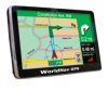
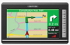
New RV GPS Features Large High Definition Touch Screen
TeleType has released the WorldNav 7300 RV / Truck GPS featuring a high resolution 7-inch touch screen affording the user a large map viewing area and crisp graphics. The RV setting allows configuration of any class RV or trailer by entering any height and weight configuration. The GPS will route the driver on roads suitable for RV travel avoiding low bridges and weight restricted areas. In addition, the GPS will avoid tunnels and parkways. Includes Bluetooth and supports rear view camera. - October 23, 2010 - TeleType Co.
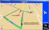
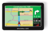
TeleType Introduces New Truck GPS Featuring Large High Definition Screen
TeleType is introducing the WorldNav 7300 Truck GPS featuring a high resolution HD 7-inch touch screen affording the user a larger map viewing area and crisp graphics. The GPS also includes Bluetooth and supports rear view camera. The GPS includes version 10 of its WorldNav navigation software featuring Lane Assist, user interface speed enhancements, improved map display, faster route calculation, and updated maps for the U.S., Canada, and Mexico. - October 14, 2010 - TeleType Co.
ThinkGeo Launches Official Wiki for Map Suite GIS Information
ThinkGeo's official wiki is the new centralized source of reference information and learning material for developers working with Map Suite, the company's suite of geographic information system (GIS) software controls for Microsoft's .NET Framework. - October 08, 2010 - ThinkGeo LLC
Leading Maritime Communications Firm Completes Installation for Large Inland Towing Fleet
Maritime technology firm Boatracs Inc., announced today that it has completed another large satellite communications fleet installation. - September 22, 2010 - Boatracs, Inc.
TerraMetrics Makes Military Training Technology's Prestigious Top 100
TerraMetrics, Inc., a leading developer of high-precision terrain-rendering technologies and global satellite imagery for aviation, simulation and geospatial markets, announced today that it has been named to Military Training Technology’s Top 100 List for 2010. The list recognizes the... - September 19, 2010 - TerraMetrics, Inc.
SPI Infrared Launches New X26 Thermal Imaging Review Web Site
Sierra Pacific Innovations, Corp. announces the launch of X26.com that features thermal camera and night vision scope reviews and thermography articles for self-directed consumer education. - August 05, 2010 - Sierra Pacific Innovations, Corp.
ThinkGeo Introduces Map Suite 4.0, The Next Generation of Its GIS Software Components
ThinkGeo has released Map Suite version 4.0, bringing support for some of the latest technologies from Microsoft, Google Static Maps API version 2, and many of the most often-requested features from their customer base. Additionally, the all-new Map Suite WPF Desktop Edition GIS control for .NET has been introduced. - June 18, 2010 - ThinkGeo LLC
Bricett Announces the Availability of High Performance Navigation Grade Accelerometers
BRICETT – manufacturer and provider of inertial products announces the availability of navigation grade quartz technology accelerometers having an excellent performance for navigation, guidance, control, and measurement applications. - June 18, 2010 - BRICETT
Bricett Announces the Availability of Tactical Grade Dynamically Tuned Gyroscopes (DTG)
BRICETT – manufacturer and provider of inertial products announces the availability of tactical grade dynamically tuned gyroscopes (DTG) having an excellent performance for guidance and control applications. - June 17, 2010 - BRICETT
Automated Taxi Dispatch Service Integrates WorldNav Navigation
Taxi dispatch with automatic turn by turn navigation has been integrated by Little Services, Inc. using the TeleType WorldNav navigation application providing a turnkey solution for fleet owners wishing to streamline dispatch and navigation functions. - April 29, 2010 - TeleType Co.
WorldNav Truck GPS Now Offers Mexico Maps
Truck drivers are being mandated to follow routes that are suitable for their vehicles. Commercial drivers are now able to cross the U.S. border to Canada and to Mexico with added confidence that they are following truck friendly routes by using the newly updated WorldNav Truck GPS. - April 08, 2010 - TeleType Co.

Trenton Motherboard Increases System Performance and Brings Intel(R) Trusted Execution Technology to Secure Network Servers
Trenton's WTM7026 motherboards support two, six-core Intel® Xeon(R) Processor 5600 series and feature PCI Express® 2.0 technology. These Westmere-EP processors offer the power savings with increased performance and computer security needed in many rackmount server applications. The Trenton WTM7026 embedded motherboard offers many I/O and option card support features designed to maximize the effectiveness of COTS rackmount computer systems. - March 16, 2010 - TRENTON Systems, Inc.
Free Truck Friendly Mapping via Google Earth
Truck drivers are being mandated to follow routes that are suitable for their vehicles. For small to midsized fleets the requirement can be an extra expense in an already challenging economy. A new program offers an economical method of determining truck friendly routes without the added expense of equipping each driver with a dedicated trucker friendly GPS. TeleType combines the use of it’s new WorldNav Truck PC software with Google Earth for an unlimited number of drivers to use free of charge - February 12, 2010 - TeleType Co.
TRENTON Single Board Computer Delivers 5x Memory Performance and 2x Interface Speed Increases
Trenton's New JXT6966 Single Board Computer Features Dual, Quad-Core Intel® Xeon® Processors C5500 Series with Integrated Memory and I/O Controllers Plus PCI Express® Gen 2.0. - February 12, 2010 - TRENTON Systems, Inc.
ThinkGeo Releases Version 5.0 of Its Cygnus Track GPS Tracking Solution, Begins Offering Free Trial
Cygnus Track, ThinkGeo's premier GPS tracking software platform, has been upgraded to version 5.0 and is now available in the affordable Starter Edition. Along with significant improvements in performance and usability, a risk-free 30-day trial is also now offered. - December 17, 2009 - ThinkGeo LLC
Tech News for US Drivers: Cheetah’s Tiny New Speed & Red Light Cam-Buster Comes with a Tiny Price Tag
Drivers now have a new tool to help them drive safely and avoid photo-enforcement tickets from the ever increasing number of automated speed and red light cameras across the USA, and they don’t need to have a GPS or expensive smartphone, or be a technical whiz-kid to use it. It’s... - November 23, 2009 - Cheetah USA LLC
ThinkGeo Issues Final Releases of Map Suite Desktop, Silverlight and Routing; Updates Entire Map Suite Line
Coming at the conclusion of the public beta, the new releases of Map Suite bring enhanced stability and performance to developers of professional mapping applications. The new final releases can now be downloaded direct from ThinkGeo's website. - November 19, 2009 - ThinkGeo LLC
Online Reseller MapMart to Offer TruEarth 15-Meter Global Satellite Imagery
MapMart.com will carry the full TruEarth 15-meter global satellite imagery product line including two new products that are tuned for applications requiring smaller dataset sizes and available in several formats. - October 22, 2009 - TerraMetrics, Inc.
TeleType Truck GPS Product Line Expands to include Canada
TeleType to include Canadian truck routing for it’s North American WorldNav Truck GPS product line. The company offers several GPS models specifically designed for truck drivers. The WorldNav portable truck GPS models feature navigation software which allows truck drivers to create routes based on the exact size and weight of their vehicles. The new software offers U.S. and Canadian truck routes, truck stop listings, CAT scales, and offers multiple point routing. - October 15, 2009 - TeleType Co.
Rotomotion SR20 Only Unmanned Aerial System to Complete Multiple High Wind Flights During Defense Systems & Equipment International 2009
Rotomotion, a manufacturer of VTOL UAV / UAS for the civil, private and military markets, conducted demonstrations at the recent DESI2009 conference. The Rotomotion SR20 was the only UAV to conduct flight operations, mainly due to heavy winds. - October 12, 2009 - Rotomotion, llc
Quantum3D Selects TerraMetrics 3D Terrain-Rendering Engine and Global Satellite Imagery for Whole-Earth Rendering Applications
TerraMetrics, Inc., announces that Quantum3D, the leading developer and manufacturer of COTS, open-architecture, real-time visual computing solutions, has licensed the company's 3D terrain-rendering engine and global satellite imagery to add a new global 3D rendering capability to IData, Quantum's Human Machine Interface toolkit. - October 08, 2009 - TerraMetrics, Inc.
TerraMetrics Receives Military Training Technology's Top 100 Award
TerraMetrics, Inc., has been recognized as a Military Training Technology Top 100 company for the fourth year running. The annual listing honors companies that have made a significant impact on the military training industry. - September 30, 2009 - TerraMetrics, Inc.
ThinkGeo Releases Map Suite Geocoder 3.0 Beta 1
Map Suite Geocoder 3.0 offers versatile and high-performance conversion of latitude and longitude coordinates to street addresses and vice-versa in a native .NET component for application developers. This new product enables .NET software developers to add totally customizable street address lookups and reverse geocoding to their map-enabled applications. - September 20, 2009 - ThinkGeo LLC
ThinkGeo Releases Map Suite Routing, Brings Route Plotting and Turn-by-Turn Directions to Map Suite
Map Suite Routing makes it easy for developers to add routing features to their Map Suite applications, including turn-by-turn directions, waypoint support and area avoidance. Now, developers can deliver a whole new level of features and functionality to their customers through their Map Suite GIS projects. - August 14, 2009 - ThinkGeo LLC
TeleType Releases Free WorldNav Waypoint Converter
TeleType has released a free converter allowing waypoints from other GPS systems stored in text files to be converted into WorldNav GPS waypoints. The company offers development tools to aid programmers in developing their own GPS based applications. - June 12, 2009 - TeleType Co.
ThinkGeo Announces Map Suite Desktop Edition 3.0 Release Candidate, Other Product Refreshes
Based on several months' worth of feedback from its customers, ThinkGeo today announced the availability of a Map Suite Desktop Edition 3.0 Release Candidate. Also available are updated versions of the other members of its Map Suite 3.0 family of GIS software products, each featuring a host of additions, bug fixes, and API improvements. - May 27, 2009 - ThinkGeo LLC
ThinkGeo Releases Map Suite Silverlight Edition 3.0 Beta 1
For developers seeking to create visually rich, multiplatform GIS applications with Microsoft Silverlight, ThinkGeo's new Map Suite Silverlight Edition GIS control provides a powerful yet easy-to-use solution. Developers can use it to add maps with advanced functionality like spatial queries, interactive shape drawing and editing, point animation, distance calculations, rich tooltips and markers, projections and much more. - April 16, 2009 - ThinkGeo LLC
Lake Monitoring System at Lake Dardanelle an Unexpected Catch for B.A.S.S. Elite Series Tournament Participants
Researchers from the U.S. Geological Survey Arkansas Water Science Center installed a Lake Diagnostic System (LDS) in Lake Dardanelle for the Diamond Drive Bassmaster Elite Series Tournament, which will take place from March 26 - 29, 2009. The LDS is a floating system that collects water temperature and dissolved oxygen data every 30 seconds, and has above surface meteorology sensors for monitoring air temperature, wind speed and direction, and other meteorological data. - March 26, 2009 - Precision Measurement Engineering, Inc.
ThinkGeo Releases Map Suite Web Edition 3.1, Services Edition 3.1 and World Map Kit Extension
ThinkGeo has just released the final versions of its Map Suite Web Edition 3.1, Map Suite Services Edition 3.1 and Map Suite World Map Kit extension products. Formerly in beta testing, these three GIS software products will make mapping applications developed on Microsoft's .NET platform even... - January 28, 2009 - ThinkGeo LLC
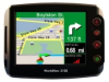
TeleType Expands Truck GPS Product Line: New 5’’ Inch Model Released
TeleType has now released the WorldNav 5100 series portable GPS for truck drivers. This new 5’’ inch device accommodates drivers preferring a slightly smaller screen than the top of the line 7” models currently offered by the company. The 5100 model provides the driver with an optimized viewing area while remaining compact in size. These portable GPS models feature navigation software which allows truck drivers to create routes based on the exact size and weight of their vehicles. - January 15, 2009 - TeleType Co.
ThinkGeo Releases Map Suite Desktop Edition 3.0 Beta 1
ThinkGeo is excited to announce the release of Map Suite Desktop Edition 3.0 Beta 1, the next generation of its professional .NET native GIS control for desktop application development. Desktop Edition 3.0 includes both WPF (Windows Presentation Foundation) and Winforms controls, and comes with a completely redesigned and streamlined API, charting & graphing, support for thousands of projections, the ability to integrate your own data formats, and much more. - November 21, 2008 - ThinkGeo LLC
ThinkGeo Releases Map Suite World Map Kit Beta
ThinkGeo is excited to announce the release of the Map Suite World Map Kit Beta, a global data and rendering plugin for its Map Suite 3.0 family of GIS software components. The World Map Kit delivers a complete set of map data covering the entire world, plus professionally-designed rendering logic that produces attractive maps right out of the box. Just add a few lines of code to your Map Suite application, and you're ready to go. - October 02, 2008 - ThinkGeo LLC
ThinkGeo Releases Map Suite Web Edition 3.0 Beta 1
ThinkGeo is excited to announce the release of Map Suite Web Edition 3.0 Beta 1, the next generation of its professional ASP.NET GIS server control. Web Edition 3.0 includes a completely redesigned and streamlined API, integrated AJAX UI controls, charts & graphs, dynamic panning with automatic map fill-in, customizable tooltips, markers and balloons, more spatial data formats, and much more. - August 13, 2008 - ThinkGeo LLC

Trenton Technology Introduces TQ9 Graphics-Class Single Board Computer/System Host Board
The new Trenton TQ9 board is a PICMG 1.3 system host board (SHB) that offers a wide variety of multi-core processor options on a board with the extensive I/O support needed in today’s complex system applications. The TQ9 board features the latest dual- and quad-core Intel® CoreTM 2 Processor & Intel® Q35 Express Chipset capability. - April 16, 2008 - TRENTON Systems, Inc.

TeleType Releases Commercial Truckers GPS with Hazmat Routing
TeleType offers portable GPS navigation system for professional truck drivers, bus drivers, and RV'ers. The product now supports 10 levels of Hazmat routing and offers commercial truckers the ability to enter the size and weight of their vehicle to effectively navigate based on vehicle characteristics. - March 10, 2008 - TeleType Co.
TeleType Releases Portable GPS for Commercial Truckers
TeleType offers portable GPS navigation system for professional truck drivers, bus drivers, and RV'ers. - February 08, 2008 - TeleType Co.
Azentek Rocks SEMA with the Atlas CPC-1000
Azentek, LLC., in partnership with Microsoft, made quite a bit of noise at this year’s SEMA show with the all-new Atlas CPC-1000 in-vehicle computer, preloaded with high-fidelity digital music provided by MusicGiants. The Atlas is a double-din “all-in-one-chassis” multimedia... - November 09, 2007 - Azentek
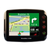
TeleType Portable GPS Navigation Product Awarded GSA Advantage Contract
The TeleType GPS WorldNav 3100 Premium has been awarded a GSA Advantage contract allowing government agencies to easily purchase this portable navigation system. - August 17, 2007 - TeleType Co.
TeleType Releases GPS Navigation Developer Tools
TeleType offers GPS navigation SDK and ESRI converter tools for implementing navigation solutions on Windows CE portable GPS systems, laptops and Windows XP based devices. - July 30, 2007 - TeleType Co.
Precision Measurement Engineering, and Centre for Water Research Provide System for Water Quality Management
The Lake Diagnostic System (LDS) produced and manufactured by Precision Measurement Engineering (California) and Centre for Water Research (Australia) provides critical water quality management data to researchers and lake managers worldwide. Two LDSs were recently installed in Thomson Reservoir, Australia for Melbourne Water. They will be recording and transmitting data on temperature, dissolved oxygen, wind speed, meteorology, and water level. - May 26, 2007 - Precision Measurement Engineering, Inc.
Photovac Announces Expansion of Team
Photovac, Inc. is pleased to announce the addition of Lon Loken, Olga Pavleyeva, and Dennis Wrona to its team of talented professionals. Lon Loken joins the company as the Vice President of North American Sales and Marketing to strengthen Photovac’s sales efforts in both North America and... - February 08, 2007 - Photovac, Inc.
GT-22 Night Vision Weapon Sight
N-Vision Optics introduced its new GT-22 Night Vision Weapon Sight at the Shot Show 2007. The GT-22 is a night vision weapon sight which can be mounted in front of a daytime scope on any weapon equipped with a MIL-STD 1913 (Picatinny) rail. The GT-22’s optical centerline is 1.5 inches... - January 23, 2007 - N-Vision Optics
N-Vision Optics at IACP Annual Conference
N-Vision Optics will be showcasing the full line of their night vision devices at IACP 2006 Annual Conference in Boston, October 15-17. The new design of the GT-14 night vision monocular, which is already being thoroughly used by many police departments all over the US, will also be available... - October 14, 2006 - N-Vision Optics
Night Strike Tactical Night Vision Monocular and NS15 Dual-Tube Night Vision Binocular
N-Vision Optics introduces its new high performance night vision monocular, the Night Strike. Developed based on experience of manufacturing night vision equipment for law enforcement and military, the Night Strike was created with a bigger objective lens, making it an ideal system for longer range... - September 20, 2006 - N-Vision Optics
New Portable GPS Navigation System with Music Player, and Picture Viewer
TeleType Company has just released a successor to its innovative product line that blends cutting-edge vehicle GPS navigation with MP3 and Video player technology. The all-in-one device, called the WorldNav 3100, is a portable car navigation system that offers door-to-door GPS guidance with simple... - July 09, 2006 - TeleType Co.
De Beers and Gedex Sign Strategic Agreement
Gedex Inc., a private Canadian corporation, has completed a strategic agreement with De Beers, the world’s largest diamond mining group, which will assist in the commercialization of Gedex’s new resource exploration technology. De Beers has contracted with Gedex to use its unique... - June 29, 2006 - Gedex Inc.